Cairo: Issues in the Metropolis (Competency 2)
Information / Instructions
- - - - - - - - - - - - - - - - - - - - - - -
Note: There is a sister Competency 1 scenario available too:
Cairo: A Metropolitan Territory scenario
Technical: You need to Duplicate this scenario to use it, since many of the tasks require you to examine then edit the point descriptions.
- - - - - - - - - - - - - - - - - - - - - - -
Concepts to consider include "growth, imbalance, multi-ethnicity and slums" amongst others.
Questions to consider should focus on how Cairo "is a major urban centre where power and services are concentrated, and where issues abound. People in the surrounding region and even in the national territory as a whole are drawn to it." And, interpretations should help students consider how to "Get around in Cairo" and help them reflect on other issues such as "Finding Housing" and "Waste Management", etc. (QEP page 276)
Read up on Cairo Territory!
The tasks outlined here are intended to help you understand and interpret the issues outlined in the second information icon. The technique of using a Geographic Sketch is outlined in detailed here
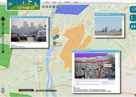
Task 1: Cairo Traffic Facts and Solutions

After reading the texts on Cairo's road developments in the Information icon, exam both the bridge icon and the highway icon very closely, zoom in, open it, and read the information and the tasks.
Choose only one of these points (the bridge or road location) and complete the tasks inside it.
Task 2: Public transit Facts, Solutions, Challenges
 Examine the text, photos and links on Cairo Public Transit in the Information icon. Or use Google Image search to find pictures of "Cairo Metro" or "Cairo Transit.) (Or use http://www.photosforclass.com)
Choose a photo you can interpret. Choose a photo that
a) you are able to exactly locate on the map!
and
b) which shows how transit projects in Cairo are filled with issues and problems, like: "they are hampered by the chaotic development of the city, as well as by dense traffic and poor road conditions", and like how transit systems are trying to service the "expanding working-class neighbourhoods, which are often far from the city centre".
Place that photo on the map using the POINT OF INTEREST marker tool ( ) and add an appropriate icon. Use both the description area and by editing and drawing on the photo, show how that photo illustrates Cairo's Transit system and its challenges.
Task 3: Pollution as an issue in Cairo
Read the section on Air Quality in the Information icon. Scan the list of web sites there and also the general web links provided below.
Closely examine all the points with the blue pollution-related icons. (Open and read what is there, zoom into the area, view the photos attached and follow any links to read up on the issues and problems these photos demonstrate)
Choose only ONE of the blue pollution locations. Follow the "task" instructions inside, which ask you to both write an explanation and your interpretation of the issue, AND also to sketch on the photo how that issue is being demonstrated.
Housing:
Informal Settlements :Ashaw’iyyats
http://favelissues.com/2010/10/20/informal-settlements-ashaw’iyyats/
CAIRO Probs and Solutions http://www.scribd.com/doc/14772947/CAIRO-Probs-and-Solutions#scribd
Creative Solutions for Affordable Housing
https://ashokaarabworld.wordpress.com/2009/07/06/creative-solutions-for-affordable-housing-fixing-egypt’s-housing-problem-the-ashoka-way/
Informal housing in cairo; problem or solution?
https://ellieflynn92blog.wordpress.com/2013/05/06/informal-housing-in-cairo-problem-or-solution/
Living people in Cairo’s city of the dead
http://www.todayszaman.com/life_living-people-in-cairos-city-of-the-dead_200122.html
The Housing Situation for Expats in Cairo
http://www.internations.org/cairo-expats/guide/moving-to-cairo-15457/the-housing-situation-for-expats-in-cairo-2
Traffic:
Egypt Cairo Ring Road at
http://www.egypt-cairo.com/cairo_ring_road.html
Ring Road Map at
http://www.ahmedhamdyeissa.com/relchiwy.htm
Cairo’s DIY Highway Exit, an Urbanist Movement Grows
http://nextcity.org/daily/entry/in-the-traffic-of-cairos-diy-highway-exit-an-urbanist-movement-grows
In the fast lane (Al-Ahram Weekly)
http://weekly.ahram.org.eg/2003/648/feature.htm
The big squeeze (Al-Ahram Weekly)
http://weekly.ahram.org.eg/2002/613/li2.htm
Transit:
Cairo Metro, Egypt
http://www.railway-technology.com/projects/cairo-metro/
CAIRO at UrbanRail
http://www.urbanrail.net/af/cairo/cairo.htm
Transport in Cairo http://en.wikipedia.org/wiki/Transport_in_Cairo
Africa’s only subway soothes Cairo’s traffic woes, slightly
http://www.voanews.com/content/a-13-2006-06-29-voa25/312901.html
Missing the bus (Al-Ahram Weekly)
http://weekly.ahram.org.eg/2005/736/fe1.htm
Pollution:
Living in Cairo Is the Same as Smoking a Pack a Day
http://www.alternet.org/story/65852/living_in_cairo_is_the_same_as_smoking_a_pack_a_day
Improving Air Quality and Health for Millions of Egyptians
http://www.chemonics.com/OurWork/OurProjects/Pages/Cairo-Air-Improvement-Project.aspx
A black cloud over Cairo (cause = burning fields) https://earthdata.nasa.gov/featured-stories/featured-research/black-cloud-over-cairo
Pollution in Egypt: Global Consequences to Poor Environmental Practices
http://triplehelixblog.com/2013/05/pollution-in-egypt-global-consequences-to-poor-environmental-practices/
In Cairo the noise pollution can be a killer
http://www.terradaily.com/reports/In_Cairo_the_noise_pollution_can_be_a_killer_999.html
Egypt's cement firms overcome gas shortages by importing coal http://www.reuters.com/article/2014/11/05/egypt-cement-coal-idUSL6N0SU2YB20141105
Air pollution caused by coal in cement factories in Egypt
https://www.youtube.com/watch?v=Bfbzklx6qYQ
Two main polluting industries, cement and charcoal, pledge to reduce emissions http://www.egyptindependent.com/news/two-main-polluting-industries-cement-and-charcoal-pledge-reduce-emissions
Cairo City large detailed tourist map:
http://www.vidiani.com/?p=8305
Visitors Map from URHC project site:
http://www.urhcproject.org/VisitorMap
Giza and Cairo Tourist Map
http://www.mappery.com/map-of/Giza-and-Cairo-Tourist-Map
Cairo maps at mappery
http://www.mappery.com/city-maps-Cairo
Cairo Junior Worldmark Encyclopedia of World Cities
http://www.encyclopedia.com/topic/Cairo.aspx
Urban Regeneration for Historic Cairo
http://whc.unesco.org/en/historic-cairo-project/
Cairo :: A Quick Intro to the City (Maps indicating "Informal Settlements"
http://favelissues.com/2010/09/30/cairo-a-quick-intro-to-the-city/
New Cairo as suburban residential area for wealthy:
http://www.nytimes.com/2010/08/25/world/africa/25egypt.html?_r=0
http://archinect.com/people/project/33081521/barwa-new-cairo-egypt/33086335
GAFI site for Industrial Zone names: http://www.gafi.gov.eg/en/doingbusiness/industrialzone.aspx
Cairo Governorate list for Industrial Areas:
http://www.cairo.gov.eg/CairoPortal/investment/text%20industry%20areas.aspx?ID=10
Informal Settlements :Ashaw’iyyats
http://favelissues.com/2010/10/20/informal-settlements-ashaw’iyyats/
Cairo - Landmarks
http://www.tripadvisor.ca/Attractions-g294201-Activities-c47-Cairo_Cairo_Governorate.html
United Nations Historic Cairo
http://whc.unesco.org/en/list/89
Sacred Destinations Cairo, Egypt
http://www.sacred-destinations.com/egypt/cairo
Modern egyptian landmarks
http://egypt-landmarks.blogspot.ca/2009/10/modern-egyptian-landmarks.html
List of tallest buildings in Cairo http://en.wikipedia.org/wiki/List_of_tallest_buildings_in_Cairo
A tour of Islamic Cairo, Egypt
http://www.touregypt.net/cairo/cairoislamic.htm
Cairo Off The Beaten Path
http://www.virtualtourist.com/travel/Africa/Egypt/Muhafazat_al_Qahirah/Cairo-2008750/Off_the_Beaten_Path-Cairo-TG-C-1.html
Cairo: Issues in the Metropolis of Cairo
Competency 2: Interpret the issues in a metropolisNote: There is a sister Competency 1 scenario available too:
Cairo: A Metropolitan Territory scenario
Technical: You need to Duplicate this scenario to use it, since many of the tasks require you to examine then edit the point descriptions.
- - - - - - - - - - - - - - - - - - - - - - -
Overview:
This scenario asks students to examine and interpret issues in the "Cairo Governorate" urban territory in Egypt. Tasks and focus questions are originally based on ideas and resources from the RECITUS/LEARN resource collection on Metropolises at https://educators.learnquebec.ca/resources-edu/metropolises-cairo-montreal/Concepts to consider include "growth, imbalance, multi-ethnicity and slums" amongst others.
Questions to consider should focus on how Cairo "is a major urban centre where power and services are concentrated, and where issues abound. People in the surrounding region and even in the national territory as a whole are drawn to it." And, interpretations should help students consider how to "Get around in Cairo" and help them reflect on other issues such as "Finding Housing" and "Waste Management", etc. (QEP page 276)
Preparation:
Title: Copy this mapping scenario and its instructions for your own use using the Duplicate button. Re-title the map to include words like, "Cairo: Issues......... by YourName".Read up on Cairo Territory!
-
First, review the Geography, Population and Economy section notes in the first information icon.
-
Second, read through the various important issues that Cairo faces in the second information icon.
- Then return here when needed, to research Cairo using the appropriate resources listed at bottom of these instructions
Tasks:
The tasks outlined here are intended to help you understand and interpret the issues outlined in the second information icon. The technique of using a Geographic Sketch is outlined in detailed here
Task 1: Cairo Traffic Facts and Solutions
After reading the texts on Cairo's road developments in the Information icon, exam both the bridge icon and the highway icon very closely, zoom in, open it, and read the information and the tasks.
Choose only one of these points (the bridge or road location) and complete the tasks inside it.
Task 2: Public transit Facts, Solutions, Challenges
Choose a photo you can interpret. Choose a photo that
a) you are able to exactly locate on the map!
and
b) which shows how transit projects in Cairo are filled with issues and problems, like: "they are hampered by the chaotic development of the city, as well as by dense traffic and poor road conditions", and like how transit systems are trying to service the "expanding working-class neighbourhoods, which are often far from the city centre".
Place that photo on the map using the POINT OF INTEREST marker tool (
Task 3: Pollution as an issue in Cairo
Closely examine all the points with the blue pollution-related icons. (Open and read what is there, zoom into the area, view the photos attached and follow any links to read up on the issues and problems these photos demonstrate)
Choose only ONE of the blue pollution locations. Follow the "task" instructions inside, which ask you to both write an explanation and your interpretation of the issue, AND also to sketch on the photo how that issue is being demonstrated.
Resources
(see also links in the different points on the map):General Cairo Resources:
Cairo at http://wikitravel.org/en/CairoResources for Cairo Issues
Housing:
Informal Settlements :Ashaw’iyyats
http://favelissues.com/2010/10/20/informal-settlements-ashaw’iyyats/
CAIRO Probs and Solutions http://www.scribd.com/doc/14772947/CAIRO-Probs-and-Solutions#scribd
Creative Solutions for Affordable Housing
https://ashokaarabworld.wordpress.com/2009/07/06/creative-solutions-for-affordable-housing-fixing-egypt’s-housing-problem-the-ashoka-way/
Informal housing in cairo; problem or solution?
https://ellieflynn92blog.wordpress.com/2013/05/06/informal-housing-in-cairo-problem-or-solution/
Living people in Cairo’s city of the dead
http://www.todayszaman.com/life_living-people-in-cairos-city-of-the-dead_200122.html
The Housing Situation for Expats in Cairo
http://www.internations.org/cairo-expats/guide/moving-to-cairo-15457/the-housing-situation-for-expats-in-cairo-2
Traffic:
Egypt Cairo Ring Road at
http://www.egypt-cairo.com/cairo_ring_road.html
Ring Road Map at
http://www.ahmedhamdyeissa.com/relchiwy.htm
Cairo’s DIY Highway Exit, an Urbanist Movement Grows
http://nextcity.org/daily/entry/in-the-traffic-of-cairos-diy-highway-exit-an-urbanist-movement-grows
In the fast lane (Al-Ahram Weekly)
http://weekly.ahram.org.eg/2003/648/feature.htm
The big squeeze (Al-Ahram Weekly)
http://weekly.ahram.org.eg/2002/613/li2.htm
Transit:
Cairo Metro, Egypt
http://www.railway-technology.com/projects/cairo-metro/
CAIRO at UrbanRail
http://www.urbanrail.net/af/cairo/cairo.htm
Transport in Cairo http://en.wikipedia.org/wiki/Transport_in_Cairo
Africa’s only subway soothes Cairo’s traffic woes, slightly
http://www.voanews.com/content/a-13-2006-06-29-voa25/312901.html
Missing the bus (Al-Ahram Weekly)
http://weekly.ahram.org.eg/2005/736/fe1.htm
Pollution:
Living in Cairo Is the Same as Smoking a Pack a Day
http://www.alternet.org/story/65852/living_in_cairo_is_the_same_as_smoking_a_pack_a_day
Improving Air Quality and Health for Millions of Egyptians
http://www.chemonics.com/OurWork/OurProjects/Pages/Cairo-Air-Improvement-Project.aspx
A black cloud over Cairo (cause = burning fields) https://earthdata.nasa.gov/featured-stories/featured-research/black-cloud-over-cairo
Pollution in Egypt: Global Consequences to Poor Environmental Practices
http://triplehelixblog.com/2013/05/pollution-in-egypt-global-consequences-to-poor-environmental-practices/
In Cairo the noise pollution can be a killer
http://www.terradaily.com/reports/In_Cairo_the_noise_pollution_can_be_a_killer_999.html
Egypt's cement firms overcome gas shortages by importing coal http://www.reuters.com/article/2014/11/05/egypt-cement-coal-idUSL6N0SU2YB20141105
Air pollution caused by coal in cement factories in Egypt
https://www.youtube.com/watch?v=Bfbzklx6qYQ
Two main polluting industries, cement and charcoal, pledge to reduce emissions http://www.egyptindependent.com/news/two-main-polluting-industries-cement-and-charcoal-pledge-reduce-emissions
Resources for Area Types and Categorization:
(These sites were used mostly in Scenario 1 on Territory They are left here to help with names of regions in Cairo!)Cairo City large detailed tourist map:
http://www.vidiani.com/?p=8305
Visitors Map from URHC project site:
http://www.urhcproject.org/VisitorMap
Giza and Cairo Tourist Map
http://www.mappery.com/map-of/Giza-and-Cairo-Tourist-Map
Cairo maps at mappery
http://www.mappery.com/city-maps-Cairo
Cairo Junior Worldmark Encyclopedia of World Cities
http://www.encyclopedia.com/topic/Cairo.aspx
Urban Regeneration for Historic Cairo
http://whc.unesco.org/en/historic-cairo-project/
Cairo :: A Quick Intro to the City (Maps indicating "Informal Settlements"
http://favelissues.com/2010/09/30/cairo-a-quick-intro-to-the-city/
New Cairo as suburban residential area for wealthy:
http://www.nytimes.com/2010/08/25/world/africa/25egypt.html?_r=0
http://archinect.com/people/project/33081521/barwa-new-cairo-egypt/33086335
GAFI site for Industrial Zone names: http://www.gafi.gov.eg/en/doingbusiness/industrialzone.aspx
Cairo Governorate list for Industrial Areas:
http://www.cairo.gov.eg/CairoPortal/investment/text%20industry%20areas.aspx?ID=10
Informal Settlements :Ashaw’iyyats
http://favelissues.com/2010/10/20/informal-settlements-ashaw’iyyats/
Resources for Area Types and Categorization:
(These sites were used mostly in Scenario 1 on Territory They are left here to help with names of regions in Cairo!)Cairo - Landmarks
http://www.tripadvisor.ca/Attractions-g294201-Activities-c47-Cairo_Cairo_Governorate.html
United Nations Historic Cairo
http://whc.unesco.org/en/list/89
Sacred Destinations Cairo, Egypt
http://www.sacred-destinations.com/egypt/cairo
Modern egyptian landmarks
http://egypt-landmarks.blogspot.ca/2009/10/modern-egyptian-landmarks.html
List of tallest buildings in Cairo http://en.wikipedia.org/wiki/List_of_tallest_buildings_in_Cairo
A tour of Islamic Cairo, Egypt
http://www.touregypt.net/cairo/cairoislamic.htm
Cairo Off The Beaten Path
http://www.virtualtourist.com/travel/Africa/Egypt/Muhafazat_al_Qahirah/Cairo-2008750/Off_the_Beaten_Path-Cairo-TG-C-1.html